


Imagine Tacoma with a web of streetcar lines throughout the city, shuttling people to and from work and leisure. Some people view such fanciful ideas as images of Tacoma’s progressive future. For historians however, the idea of streetcars within walking distance of every point in Tacoma was a real part of its past. Today, people can see where the long-abandoned tracks once ran, if they know the clues hiding in plain sight.
The first two streetcar lines in Tacoma were constructed in 1888, along the lengths of Pacific and Tacoma avenues, and consisted of cars pulled by teams of horses. Tacoma then became the central hub of streetcars routes around Pierce County in 1890, with the Tacoma and Steilacoom Railway Co. that ran 12 miles from downtown Tacoma to 6th Avenue. The route then ran through what is now University Place and down to Chambers Bay on its way up Steilacoom’s Lafayette Street. The train company was the world’s first interurban streetcar system.
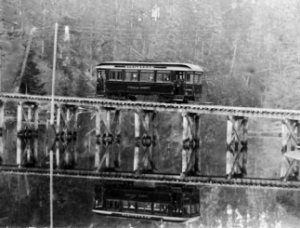
But it quickly had siblings that created a web of independently operated trolley lines, streetcar tracks, and short-line railroads around the county. One route went from Tacoma and ran along South Tacoma Way. Another track darted from Tacoma, across the prairie, to what is now Mountain View Cemetery. American Traction Line went to Manitou and Lake City. Another went down Pacific Avenue to Spanaway Lake, while others ran from downtown to residential neighborhoods of the North End, the Eastside, and West Tacoma. It was, after all, an age before cars.
By around 1912, the city boasted 125 miles of streetcar tracks, almost 30 streetcar lines, as well as an electric interurban rail connection to Seattle. Tacoma Rail and Power had stations around South Tacoma and what is now the suburban city of Lakewood and had an annual ridership that topped 3 million passengers a year. The business viability of so many companies operating was short lived, however. Companies either shut down just years after starting or merged with other companies to spread out the costs of operating the tracks.
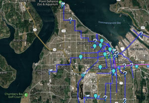
One technology-minded historian has gathered information about all of the lines that were still in operation in 1923, with historical notes about specific stops and notable events in the tracks history and put the information on an interactive Google Map that continues to draw web traffic and interest.
By 1928, however, Tacoma’s city directory shows only three companies left. The directory shows that the Pacific Traction Co., which ran tracks to American Lake; the Tacoma Railway and Power Co., which ran to Steilacoom; and the Puget Sound Electric Railway, which ran lines to Kent and Seattle, were run from the same office.
The whole system died out by the mid-1930s, only to restart with the Sound Transit vote of 1996, which approved a tax that would establish yet another light rail line. The 1.6-mile Tacoma Link that runs from the Tacoma Dome Station to the city’s Theater District went live in mid-2003, marking the return of commuter rail to Puget Sound after an absence of more than 70 years. In a quirk of history, the route it runs is one that streetcars did at one time.
Where to Spot the Clues
Glimpses of the tracks can be seen around Tacoma if you know how to spot the signs. Sure, there are memorial paving stones and markers dotting the city, like those around the Pagoda at Point Defiance Park, but there are also more subtle clues a streetcar once ruled the road.
While much of the steel used in the tracks was removed and sold as scrap, the ties and concrete anchors were routinely left in place and simply paved over. Tacoma road crews know all too well the long legacy of the city’s streetcar lines. They review old trolley maps every time they do road work, so they can prepare for handling any ties or rails left when the road was created.
The remnants of the former streetcar lines are also blamed for about 10 percent of the potholes in the city. The potholes come when the wooden rail ties decay into pulp with the passage of decade and create mini air pockets under the pavement. Those eventually collapse and create ruts and potholes crews then must patch.
“You not only see them, but you can feel them in your teeth,” said Tacoma Design Team Engineer Dan Seabrands, noting that sometimes drivers can even see patterns in the ruts where blocks of tracks have since decayed and caused potholes.
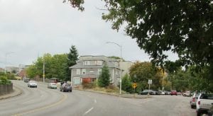
Perfectly angled corners at an intersection are clues a streetcar station ran by since that would be where people would get on of off the cars. One example of that is at South 12th and South Proctor streets, which is located next to a large commercial building that was built in 1895 and is now, oddly enough, called the Old Trolley Building.
An even less obvious clue is the sight of an old building that has an outer wall edging the sidewalk. That suggests a streetcar ran by because the road was later widened to accommodate car traffic by shifting the sidewalk toward the building.
Another sign is an unusually wide intersection with five or six streets converging at the same point, such as where Sprague meets 6th and Division avenues. A handful of streetcars merged at that point.
“Really, anywhere a street makes a really weird dogleg is likely where the streetcars ran,” said Russell Holter, a local rail historian and author of a book detailing Tacoma’s largest streetcar disaster.
A prime example of an odd intersection is the odd triangle where Yakima Avenue and I Street meets 6th Avenue because that was where streetcars would stop at Wright Park and turn around.
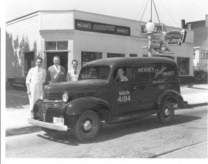
Another clue a street once had a streetcar line is if a neighborhood grocery or tavern operates along an otherwise residential street. Hank’s Corner Bar and the Corner Grocery Store on the North End’s stretch of K Street, for example, shows that a station was once at that corner, as does the Park Avenue Tavern in South Tacoma.
“That was another clue that you were on a trolley line,” Holter said.
Once you see the signs, they are tough to stop seeing, even while traveling on the roadway at 35 miles per hour.


