


By Courtney Murphy
 When American pioneer James Longmire and his exploration party first set eyes upon the south side of Mount Rainier in the mid-1800s, his daughter-in-law, Martha, is said to have exclaimed, “Oh, what a paradise!”
Located 19 miles east of the Nisqually entrance, the Paradise area of Mount Rainier National Park lives up to its name with breathtaking sights, up-close views of the mountain and hundreds of acres of wildflower meadows.
In the winter, Paradise receives on average 16.3 meters of snow and is full of families snowshoeing, cross-country skiing and tubing in the snow. In the summer, however, Paradise turns into a thriving tourist destination. The iconic, old-fashioned Paradise Inn attracts vacationers from around the world, flocking to visit one of the nation’s largest natural attractions.
For hikers of all skill levels, Paradise truly is a paradise; several trailheads of varying difficulties depart from the visitor center. One of the most popular, and also most difficult, is the Skyline Trail. Although the hike is only 5.5 miles, it contains a steady 1,500-feet of elevation gain.
A few weeks ago, my friends and I — all fairly experienced hikers — decided to tackle Skyline. While it was not the lengthiest or most remote hike we had completed, it brought its own challenges and made for a beautiful and fulfilling day.
Pre-hike Preparation
If you aim to complete the entire hike, make sure you are comfortable climbing steep gradients. The trail is often populated with casual tourists and little kids, but don’t let their presence on the hike fool you; many of these people turn around at Glacier Vista and choose not to continue, unenthused by the prospect of more rigorous climbing.
If you plan on doing the full hike, make sure you have adequate water and snacks to refuel after stretches of prolonged climbing. My group brought around two liters of water each and packed a lunch to eat at Panorama Peak.
Wear comfortable hiking or athletic shoes. Although the first section of the trail is wide and paved (though steep), some sections are heavy with shale, rocks, and boulders. You may even find yourself trudging through some mud here and there, which makes waterproof shoes helpful. Be sure to dress in layers. The weather at Paradise is often unpredictable and can change quickly. When we went, the temperature was a comfortable 72 degrees, but I appreciated a light jacket at the higher elevations and when it was windy.
Have a map of Mount Rainier National Park handy. Skyline is well marked, but the trail system before the bulk of the trail is intricate and somewhat confusing. If you do not have one previous to arrival, you can pick one up at the Jackson Visitor Center near the Paradise Inn.
The Hike
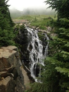
We left our house in Olympia at 6:30 a.m. and arrived at Paradise around 9:00 a.m. After exploring the Paradise Inn for a while, we started on the paved portion of the trail. We decided to hike the trail counter-clockwise so our incline was more gradual. This first portion of the hike meanders through spacious meadows full of lupine and other wildflowers. Some viewpoint trails intersect with Skyline at this point, so feel free to take a detour if you wish.
After you pass Myrtle Falls and the Lake Trails turnoffs, the trail rises with switchbacks and stone-cut staircases. With each step and foot gained in elevation, more and more of the Cascade range becomes visible.
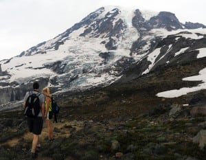
From the switchbacks, hike along the Nisqually Glacier toward the Pebble Creek junction, which leads to Camp Muir where climbers who aim to summit Mount Rainier spend the night. We deviated from the Skyline Trail slightly onto a rocky path labeled the High Skyline Trail. The lower trail, deemed a shortcut by some, leads diagonally across a large snowfield. This portion of our hike was quite rugged, but well worth it because of the close-up view of the mountain. At about 7,000 feet there is no higher point than the mountain itself.
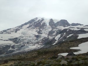
The High Skyline meets back with the lower offshoot at Panorama Point. Many people choose to take pictures in this location due the area’s sweeping views of the Cascades.“Without hiking too far into the mountains, [we] were able to see great views of Rainier,” said Peyton Murphy, my brother and of the hikers in the group. On a good day, even Mount Hood is visible. My hiking group ate lunch here and played with the trail’s other residents, the plentiful hoary marmots.
From here, the hike consists of mostly downhill staircases. We encountered a lot of hikers climbing the trail clockwise. The descent was easy, and we were soon back at the visitor center area. My group thoroughly enjoyed the hike, and some went again a few weeks later.
If you are interested in hiking the Skyline Trail, visit http://www.wta.org/go-hiking/hikes/skyline for driving directions.